

The coast of the ancient Caspian Sea… Beautiful valleys and foothills left somewhere far behind. Mountain gorges with loud waterfalls and sparkling mountain rivers disappeared like mirages in desert. Steep slopes covered with juniper trees and colourful carpet of spring primrose are not seen anymore. Only from time to time, narrow strip of the sea flickers at the very edge of the horizon, and only monotonous desert landscape spreads arounf for hundreds of kilometres.
But after some time, you began to understand that first impression was deceptive and this is exactly the place of endless desert where interesting discoveries expects for you. First of all, this is a unique opportunity to see and hear the breath of the earth that shoots out of its bowels. This is because of mud volcanoes, which are ancient geological formations on the territory of the country and still active along the Coast of the Caspian Sea. Tens and event hundreds of millions of years ago, underground elemental forces was raging there. Today, they are like fairy-tale genies hiding in abysses and waiting for their time to break free spreading apart and straightening the rocks that buried them.

Vulcan is a god of fire in Greek mythology and all flaming fire-breathing mountains are referred to as volcanoes. Currently existing hot springs and mud volcanoes have close relation with such magmatic volcanic activity. It should be admitted that surely they are not able to be compared with their elder brothers by sizes and scale of activity although they look like models of real magmatic volcanoes. Cone and crater are presented which throw periodically mud masses and gases on the surface, sometimes with hot water and oil.
Existing mud volcanoes are active ever-changing geological objects. There are only small ridges and craters filled with water, muddy water and oil instead of cones. There are only some heights formed by petrified material of eruptions left from ancient volcanoes.
Thus, mud volcanoes, which are still active on the territory of the country (there about half of them from total amount), provide constantly updated information to the scientists. In other words, these are natural super deep wells that reach complex of Mesozoic sediments. Geologists A. A. Alizade and N. O. Nazarov, who study mud volcanoes of western Turkmenistan for many years, established that they are direct signs of presence of oil-and-gas in the region.
These volcanoes of the south-west of Turkmenistan are located on the area of more than 300 by 100 hundred kilometres. Then why mud volcanoes are located there? It is explained by the following: huge hollow (with ten kilometres depth) filled with sea sedimentations of Neogene age like clays, sandstones, marls, loose and loamy sands was formed there. It was exactly so called West Turkmen lowland that became favourable place for formation of volcanoes. As a rule, high pressure of top layers appears at the presence of such powerful sedimentations. Clay and sand filled with water come in to motion. High temperature, presence of gas, condensate, oil, waters containing different chemical elements enhance the movement of plastic masses of liquefied substance. While being the liquids and under high pressure, these substances stream up along the cracks to the surface breaking the rocks on their way. However, movement of oil fluids at depth does not stop during formation of volcanoes. Hydrocarbons saturate porous masses of breccia what leads to formation of large oil and gas fields.

Mud volcanoes of western Turkmenistan make breaking range of hills that start from the south at Essenguly settlement and end up at Cheleken (Hazar). Further, this range goes to shelf part of the sea toward the Apsheron Peninsula. It is interesting that due to fluctuation of the Caspian Sea, mud volcanoes could be above and under water.
In the middle of Sarmatian age, approximately 10 – 12 million of years ago, the reduction of the giant sea basin, which occupied the whole area of Turkmenistan and adjoining territories, has started. As a result of those tectonic movements, the group of volcanoes was formed up in the south of the country in Chikishlyar region, where Hazar State Reserve exists. There are Boiling Hill, Ak-Patlavuk, Kalitsky Volcano, Tuynukli, Keymir group, Porsy among them. Having visited these places, we ensured that Ak-Patlavuk volcano is most active one.
This volcano is undoubtedly world scale geological monument of nature. Its acting crater is presented by elevation with uneven edges. There are dome-shaped bulges on the top of the volcano caused by strong eruption. The edges of the dome that rises almost for 100 meters above the plane are cut with by rapid mud streams, which formed up deep ravines and depressions. There is crater lake of 200 meters diameter with acting gas and mud eruptions in the centre of the main dome. The activity of other volcanoes almost stopped. For example, there is only one small knoll left on Boiling Hill volcano, from which mud eruptions occur.
To the North, “wandering volcano” is located near Chikishlyar settlement. It was seen in 2006 in the sea approximately in 150 – 200 meters from shoreline. In this year, it appeared on land. Now Caspian waters wash its western slopes and edges of the hill rise above the sea on 5 – 6 meters. Chikishlyar volcano is different from others by its funnel-shaped, ideally round crater with 60 m diameter. There is a lake formed up in the crater, its water has yellowish and greenish tint.

The same ideally round crater but of bigger size is located near Keymir, few kilometres away from Chikishlyar settlement. This acting volcano is characterized by the absence of the cone. It has a shape of large funnel of 200 meters in diameter and steep slopes of 10 meters height.
Volcanoes Ekerem (buried) and Gyok Patlauk rising more than 150 meters above sand plane are included in northern group of Keymir – Chikishlyar area. This volcano is unusual, it is covered with deep “wrinkles”, its slopes are cut with erosion gutters, which was formed by running streams of heavily gassed and emulsified mud. Judging by sediment layer, the volcano changed twice its eruption point. Ak-Patlauk and Gyok-Patlauk volcanoes, more than other, remind mud hills of the Kerch Peninsula. There are the same craters with even slopes and round lakes, which level is constantly changes.
Calm activities of volcanoes take turns with rough one. Sometimes during eruption, columns of mud rise for one or two meters. The eyewitnesses say that sometimes stronger eruption occur with high content of iodine and bromine. It worth mentioning that volcanic muds have healing features. Large reserves of iodine-bromine waters was found there. There is plant for production of iodine and bromine is located near Boyadag Volcano in few kilometres from Kumdag.

Boydag is translated as mountain of colours! One cannot passed by those beauties, which were presented by the nature to this place. This volcano is located at the very East in the range of others. It is one of the biggest and acted for almost 5 million years. Currently, Boyadag volcano is represented by heavily broken hill extended almost along the latitudinal direction for more than 20 km. this geological structure is cut by numerous of cracks. Eruptions of mud and breccia.
The column-like top of this mountain Karaburun, a stem of fossilized breccia, which froze with all its mass in crater of volcano, can be seen from many tens of kilometres. Fastened with salts and saturated with bitumen, the breccia appeared stronger than rocks of the cone, which broke apart and fossilized crater with 40 meters of height remained as sublime monument of grandiose eruptions of large volcano. The slopes of Boyadag are formed with grey and light-grey clays. They are interchanged with red and brown clays. Everything is painted in rich red and brown shades. These are extremely bright colours!
The range of mud volcanoes stretched from Boyadag straight to the west via Balkanabat to Cheleken. This is exactly where most powerful eruptions of Aligul volcano occur. Some of the clods of rocks, thrown out from big depths, reach 2 – 3 meters in diameter. Certain volcanoes like Porsugel and Pink Porsugel present crater lakes.

Not many people know that volcanic activity is continuing in the West of Turkmenistan and volcanoes are still alive. Study of “live” volcanoes shed the light to solution of many issues of geology. It is no mere chance that from ancient times volcanoes and volcanic rocks were closely related to different deposits of minerals. World famous scientist I. M. Gubkin, having studied mud volcanoes of Turkmenistan and Azerbaijan, found out that oil deposits have to be explored where these geological objects were existed some time ago. It is no mere chance that currently, intensive development of natural resources of the region is carried out around almost all of volcanoes of Western Turkmenistan.
* * *
From Balhan towards gulf coast
Participants of expedition, including famous archaeologist H. Yusupov, palaeontologist A. Nigarov, specialists of Hazar State reserve and members of alpinist club “Agama” drove more than 2000 kilometres along the area adjacent to severe banks of unique Karabogazgol Gulf.
Leader of the project Oleg Guchgeldiyev speaks about expedition undertaken to Balkan velayat for study of tourist potential of this wonderful and beautiful but not researched and secret area:
This was unusual and very fascinating journey. The desert, always considered as lifeless and very severe, brought many wonderful discoveries. Even though the Caspian region is not so rich with architectural monuments, every hill, every picturesque gorge or upland are literally charged with energy of historical events. During this expedition, camps of ancient people, ancient flint tools of neolith, historical monuments reminding of tumultuous antiquity and unstable medieval, landscape natural monuments were studied again and marked on tourist map.
The expedition started from the south end of Big Balhan where in the beginning of the last century, Russian archaeologist A. Okladnikov discovered and describe caves where our distant ancestors used to live 10000 year ago. There, he discovered flint work tools of primitive man and ceramics of later period in caves Dam-dam-cheshme 1 and 2 and Jebel. Another famous Neolithic cave camp – Kaylyu, is located on the territory of the reserve on the slope of Gubasengir ridge and became the place of wonderful findings. There, at the foothills of northern-west spurs of Gubasengir, Russian scientists discovered ancient jewelleries. Until now, these places attract special attention of tourist.

Right after Balkanabat, the expedition visited Dasharabat spring where Russian army fort was located and according to local old residents, there was another more ancient and not yet explored stronghold. From here, the expedition made its way to the north of the country via sand plane Chilmamedkum towards pilgrimage place of local residents – Gozli-ata. After, we proceeded to Akgyr mountain range and further to the east and southeast towards Gyokdere settlement. Having explored the most interesting natural monuments around that settlement, the expedition went to the north to Avlamush well, and after, vial Tuyr settlement toward the southeast coast of the Karabogaz. Last day of the expedition was dedicated to exploration of the area of Karabogaz.
During our brief journey, the expedition familiarized with history known facts and historical events. Near Gozli-ata graveyard we discovered and studied small building where according to H. Yusupov, Hivian khans were buried. The burial site itself is located in very picturesque place and very popular among local residents and guests from Kazakhstan and Uzbekistan. But how did it originate there? In this relation, story of Gozli-ata or Uzynhasan, mystical person and spiritual leader of Balkan Turkmen tribes in the medieval is mentioned. At age of 102 years, wisdom man united Turkmen tribes against army of Sufian-khan from Hiva. It happened in 20s of XVI century. At that time, enemies turned form the rear and went down from the mountains at the place that until now called as “Kalmyk Kessen” (the pass made by “kalmyks” – this how Turkmen used to call all enemies from the north). On Akgyr ridge, we visited another historical place. There, standalone plateau, connected with the ridge by 13-meters neck, which is called as Howply-burun or Chotak by the locals, is located. This was exactly the place where according to Hivian historian Abulgazy, Turkmen warriors, who refused to pay contribution to the Khan of Hiva, felt back after three days of battle at Gozly-ata. Having blocked the neck with strong wall, which remains can be found even now, they bravely defended themselves against army of the Khan of Hiva.

It worth mentioning that territories of famous southeast Caspian gulf became witnesses of many tragic events in particular, the struggle of Massagetaen and Turkmen tribes for independence. Historical reference books testify that army of Persian King Kirush, having recovered after defeat in the battle against Queen Tomiris, stroke Massagetaes again after some tens of years. According to the legend, Achaemenids army lead by Darius, the grandson of Kiriush was met on the land of our ancestors by shepherd Sirak (Shirak), who undertook to beat Darius’s troops alone. It was exactly these waterless and lifeless areas where in V century A. C., Massageaten shepherd, saving his people, misled the enemy army. Today, after hundreds of years, while standing on Chopan-depe hill at eastern end of Akgyr ridge, it was easy to imagine how the Army of Darius used to break its through desert and to die in waterless valley and how Sirak used to exult, having risen his arms and crying : “I defeated the army!”.
The Ersary-Baba mountains, stretched by its ridge on south-east of Karabogazgol remembers the events of XIV century, when the leader of Turkmen tribe Ersary refused to marry his daughter to the governor of Iranian shakh (He does not want to marry my daughter but my people). At the battle of Avlamush well, he retrieved to the mountains with his family but was captured and killed by the invaders. There is graveyard at this place for already many centuries, which is honoured by Turkmens. In our days, one can meet pilgrims from all of the country there.

Landscape diversity of the north-west of the country can surprize not only arriving tourists. We come across wonderful landscape from limestone rocks, which reminds more of lunar rather than earth view, at a place near Begarslandag. There is natural water collector, which had rainwater for animals even in July. They are called “wadi” in the Central Asia. Canyons of eastern Karabogazgol area was very beautiful. Mountains at Gozly-Ata, brownish and at some places red-white-grey Akgyr mountain ridge and other remains of sometimes unite system of marine limestone sediments of Late Cretaceous period (60 – 65 million years ago) impress by their beauty. With help of local people, the expedition discovered more ancient and unusual natural formations at Sakkar-Yol. Huge lime stone and sand concretions, sometimes of two and three layers, laid upon narrow area of three kilometres in length near Gyokdere settlement. Geologist contends that these fossils appeared during period of the World Ocean shrink and tectonic rise of former sea bottom. There were disputes about their extraterrestrial origin but scientists proved that most solid than other soil concretions, found in this region, are of lower Cretaceous period and appeared on the Earth tens of millions years ago.

We found another area with such relict fossils named Gyok-yokush near the settlement; the concretions there had forms that are more fanciful and reached incredibly big sizes up to two meters. Camels’ favourite breeding ground at Kemal-Ata spring also impressed us with intricate forms of fossils, which stepped out from the banks of the spring and in composition with saxaul and running water, created unforgettable picture of prehistoric period. The animals feel free among this virgin nature. We met herd of wild rams near Kulandag Ridge; footsteps of goitered gazelles and leopard were observed near fresh water sources. We met partridges in green tangles of the banks and came across flock of 10 sea eagle, which included in Red Book of Turkmenistan. Absence of disturbing factors and reach food base of these sanctuary places will allow nature lovers to observe birds, predators and other animals in natural conditions.

Finally, it cannot help saying about good nature, interest and hospitality of local people. Anywhere, where the members of the expedition paid their visit, Goshoba, Gyokdere, Tuyr, Avlamush, we were warmly welcomed by plentiful dastarkhan, good advice and assistance. People entertained us with real camel chal (milk drink), provided with guides, told about local sightseeing and natural monuments. The Region possesses huge potential for development of so called “country tourism”, which combines elements of ethnographic, historic and ecological tourism.
* * *
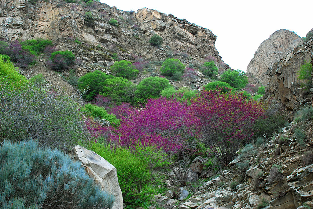
“Lunar mountains” are fantastic threshold of Sumbar Valley where Magtumguly town spreads between parted high ridges of Kopetdag Mountains. If to look at suburbs of Magtumguly from the top of Karayelchy Ridge, one can see that all area is covered with hills. But, the most interesting view of this landscape is so called Lunar mountains. These are small hills from one to eight meters in height containing large amount of salt sediments and that is why lack of plantation. Unusual bright yellowish greenish tint heightens the impression of unreality. Such unusual, extra-terrestrial landscape can be met only in Turkmenistan.

These mountains look strange: melted shapes, pinkish creamy or grey almost white colour changing after the rain and dependant on humidity, are iridescent… This picturesque area reminds of wonderful decorations created by nature for some play, which is known only to itself.
Seldom, one can meet a bush, as if occasionally appeared there, which gives for us usual Earth look to “alien landscape”.

“Lunar landscape” reminds pictures of Nikolay Rerih: yellow mound, then grey hills, far strip of blue mountains above them, after white strip of fog and blue sky on top of everything… Perhaps, it is difficult to find a person, who never dreamt to go to space trip, make few steps on unknown planet. Previously, this dream could be come true only for cosmonauts and today – only space tourists. Still, there are very few of them both previously and today. However, to admire, for example, lunar scenery it is not necessary to leave the Earth. It is enough to come to Western Turkmenistan and visit Sumbar Valley in Syunt-Hasardag Reserve. Syunt, Hasardag and Issak Mountains protect the valley from the north and Monjukly Mountains from the south and presents unique subtropical zone.

There is extraordinary favourable and soft climate in Sumbar Valley. Crisp, clear air is filled by fragrance of herbs and flowers, view of mountains and valleys landscapes are picturesque. The summer is hot here but not exhaustible, the winter is mild. There is almost no snow in the valley; it stays in the mountains only and comparing with north ridges of Kopetdag not for long time.

Barley, rye, cotton can grow here, cold resistant breed of apple and warm liking fig bear fruits, decorative palm trees are growing. Shady side gorges of upper part of Sumbar, watered by mountain rivers and especially Aydere Gorge are thickly overgrown with trees and bushes; there are many wild fruits. These are so called forest-gardens. Ash, sycamore and mountain maple trees, barberries and dog roses as well as apples, pears, walnuts, wild grapes and cherries, blackberries, figs and cherry plums are twined around by lianas and make thick, sometimes barely passable thickets. Small almond groves grow higher on the slopes, pomegranate trees can be met at well sunlit and protected from frost places. Juniper trees are high in the mountains. There is famous Parhaya Spring with mineral and hydrogen sulphide waters. This water is useful for treatment and prevention of number of diseases. It is very beautiful also near Kurujday settlement, where step slopes of the mountains rise, green meadows spread and number of springs run.

There are many sanctuaries in Sumbar and Chandyr Valleys, thousands of pilgrims come every year. There are unique archaeological monuments as well including priceless painting speaking of life of ancient people and portraying the hunting of become extinct animals.

* * *
Caves of Big Balhan
Karst is poorly developed in Big Balhan and it relates predominantly to lower cretaceous carbonate sediments. Famous Tyuz-Mergen cave is about 100 metres in length and located on the western slope of the mountain ridge. The entrance to the cave is located in the wall above precipice. After, spacious hall with 40 meters length and 5 metres height. The cave is continued through passage to another hall of 60 metres length and 20 – 40 metres width is opened. Second cave is Dum-Dum; it is located few kilometres away to the east. Its entrance is in form of niche with length of 8 metres and located between limestone stratums. Perhaps in the past, the cave could be shelter for people like those at south spurs of Balkan Mountains, which in the beginning of the last century Russian archaeologist A. Okladnikov discovered and describe caves where our distant ancestors used to live 10000 year ago. There, he discovered flint work tools of primitive man and ceramics of later period in caves Dam-dam-cheshme 1 and 2 and Jebel. . Another famous Neolithic cave camp – Kaylyu, is located on the territory of the reserve on the slope of Gubasengir ridge and became the place of wonderful findings. There, at the foothills of northern-west spurs of Gubasengir, Russian scientists discovered ancient jewelleries. Until now, these places attract special attention of tourist.

Lyama-Burun Cave presents interest on the northern slope. The entrance to the cave is difficult to access as it is located in middle part of sheer precipice with height of more than 200 metres. The entrance is quite large with 20 metres width. The cave is horizontal and consists of two spaces of several tens of metres. The first spacing is 30 metres height. Narrow inclined passage leads from there to another spacing with 20 metres height and 30 metres width. The walls have leak formations of marble onyx of honey yellowish colour with large strips and silky shine. Surely, there are other natural caves in Turkmenistan, which are not known to wide circle of specialists and speleology lovers.
We visited only largest caves of mountain Turkmenistan, real underground museums of natural science. Although they are completely studied but still present large interest and can be used for organized tourism. It is a great happiness to visit and stand under the domes of these unique natural formations and personally see inexpressible beauty of crystal kingdom.

If somebody wish to see the remains of most ancient civilization and historical monuments, then tourist route to visit ancient settlements of Meshed-Missrian can be organized. Monumental constructions of X – XIII centuries like minarets, remains of palaces, mausoleums with wondering architecture, which impress by the skill of ancient architects, remained there. There is earth compacted road of 45 kilometres distance started from Bugdayly settlement to the object.
There is one place in this region, which can be of interest of tourists – last spurs of West Kopetdag – Gyaurly Gorge, where footsteps of ancient camel, which are paleontological natural monument of world importance, are remained in layers of sandstone of Neogene. The age of footprints of ancient camel is around 2.5 million years.
Mud volcanoes of Western Turkmenistan and other places of interest of Caspian region could become not only sanctuary territory that helps scientists in sorting out of historical and geological mysteries but a zone of educational tourism.
But after some time, you began to understand that first impression was deceptive and this is exactly the place of endless desert where interesting discoveries expects for you. First of all, this is a unique opportunity to see and hear the breath of the earth that shoots out of its bowels. This is because of mud volcanoes, which are ancient geological formations on the territory of the country and still active along the Coast of the Caspian Sea. Tens and event hundreds of millions of years ago, underground elemental forces was raging there. Today, they are like fairy-tale genies hiding in abysses and waiting for their time to break free spreading apart and straightening the rocks that buried them.
Vulcan is a god of fire in Greek mythology and all flaming fire-breathing mountains are referred to as volcanoes. Currently existing hot springs and mud volcanoes have close relation with such magmatic volcanic activity. It should be admitted that surely they are not able to be compared with their elder brothers by sizes and scale of activity although they look like models of real magmatic volcanoes. Cone and crater are presented which throw periodically mud masses and gases on the surface, sometimes with hot water and oil.
Existing mud volcanoes are active ever-changing geological objects. There are only small ridges and craters filled with water, muddy water and oil instead of cones. There are only some heights formed by petrified material of eruptions left from ancient volcanoes.
Thus, mud volcanoes, which are still active on the territory of the country (there about half of them from total amount), provide constantly updated information to the scientists. In other words, these are natural super deep wells that reach complex of Mesozoic sediments. Geologists A. A. Alizade and N. O. Nazarov, who study mud volcanoes of western Turkmenistan for many years, established that they are direct signs of presence of oil-and-gas in the region.
These volcanoes of the south-west of Turkmenistan are located on the area of more than 300 by 100 hundred kilometres. Then why mud volcanoes are located there? It is explained by the following: huge hollow (with ten kilometres depth) filled with sea sedimentations of Neogene age like clays, sandstones, marls, loose and loamy sands was formed there. It was exactly so called West Turkmen lowland that became favourable place for formation of volcanoes. As a rule, high pressure of top layers appears at the presence of such powerful sedimentations. Clay and sand filled with water come in to motion. High temperature, presence of gas, condensate, oil, waters containing different chemical elements enhance the movement of plastic masses of liquefied substance. While being the liquids and under high pressure, these substances stream up along the cracks to the surface breaking the rocks on their way. However, movement of oil fluids at depth does not stop during formation of volcanoes. Hydrocarbons saturate porous masses of breccia what leads to formation of large oil and gas fields.
Mud volcanoes of western Turkmenistan make breaking range of hills that start from the south at Essenguly settlement and end up at Cheleken (Hazar). Further, this range goes to shelf part of the sea toward the Apsheron Peninsula. It is interesting that due to fluctuation of the Caspian Sea, mud volcanoes could be above and under water.
In the middle of Sarmatian age, approximately 10 – 12 million of years ago, the reduction of the giant sea basin, which occupied the whole area of Turkmenistan and adjoining territories, has started. As a result of those tectonic movements, the group of volcanoes was formed up in the south of the country in Chikishlyar region, where Hazar State Reserve exists. There are Boiling Hill, Ak-Patlavuk, Kalitsky Volcano, Tuynukli, Keymir group, Porsy among them. Having visited these places, we ensured that Ak-Patlavuk volcano is most active one.
This volcano is undoubtedly world scale geological monument of nature. Its acting crater is presented by elevation with uneven edges. There are dome-shaped bulges on the top of the volcano caused by strong eruption. The edges of the dome that rises almost for 100 meters above the plane are cut with by rapid mud streams, which formed up deep ravines and depressions. There is crater lake of 200 meters diameter with acting gas and mud eruptions in the centre of the main dome. The activity of other volcanoes almost stopped. For example, there is only one small knoll left on Boiling Hill volcano, from which mud eruptions occur.
To the North, “wandering volcano” is located near Chikishlyar settlement. It was seen in 2006 in the sea approximately in 150 – 200 meters from shoreline. In this year, it appeared on land. Now Caspian waters wash its western slopes and edges of the hill rise above the sea on 5 – 6 meters. Chikishlyar volcano is different from others by its funnel-shaped, ideally round crater with 60 m diameter. There is a lake formed up in the crater, its water has yellowish and greenish tint.
The same ideally round crater but of bigger size is located near Keymir, few kilometres away from Chikishlyar settlement. This acting volcano is characterized by the absence of the cone. It has a shape of large funnel of 200 meters in diameter and steep slopes of 10 meters height.
Volcanoes Ekerem (buried) and Gyok Patlauk rising more than 150 meters above sand plane are included in northern group of Keymir – Chikishlyar area. This volcano is unusual, it is covered with deep “wrinkles”, its slopes are cut with erosion gutters, which was formed by running streams of heavily gassed and emulsified mud. Judging by sediment layer, the volcano changed twice its eruption point. Ak-Patlauk and Gyok-Patlauk volcanoes, more than other, remind mud hills of the Kerch Peninsula. There are the same craters with even slopes and round lakes, which level is constantly changes.
Calm activities of volcanoes take turns with rough one. Sometimes during eruption, columns of mud rise for one or two meters. The eyewitnesses say that sometimes stronger eruption occur with high content of iodine and bromine. It worth mentioning that volcanic muds have healing features. Large reserves of iodine-bromine waters was found there. There is plant for production of iodine and bromine is located near Boyadag Volcano in few kilometres from Kumdag.
Boydag is translated as mountain of colours! One cannot passed by those beauties, which were presented by the nature to this place. This volcano is located at the very East in the range of others. It is one of the biggest and acted for almost 5 million years. Currently, Boyadag volcano is represented by heavily broken hill extended almost along the latitudinal direction for more than 20 km. this geological structure is cut by numerous of cracks. Eruptions of mud and breccia.
The column-like top of this mountain Karaburun, a stem of fossilized breccia, which froze with all its mass in crater of volcano, can be seen from many tens of kilometres. Fastened with salts and saturated with bitumen, the breccia appeared stronger than rocks of the cone, which broke apart and fossilized crater with 40 meters of height remained as sublime monument of grandiose eruptions of large volcano. The slopes of Boyadag are formed with grey and light-grey clays. They are interchanged with red and brown clays. Everything is painted in rich red and brown shades. These are extremely bright colours!
The range of mud volcanoes stretched from Boyadag straight to the west via Balkanabat to Cheleken. This is exactly where most powerful eruptions of Aligul volcano occur. Some of the clods of rocks, thrown out from big depths, reach 2 – 3 meters in diameter. Certain volcanoes like Porsugel and Pink Porsugel present crater lakes.
Not many people know that volcanic activity is continuing in the West of Turkmenistan and volcanoes are still alive. Study of “live” volcanoes shed the light to solution of many issues of geology. It is no mere chance that from ancient times volcanoes and volcanic rocks were closely related to different deposits of minerals. World famous scientist I. M. Gubkin, having studied mud volcanoes of Turkmenistan and Azerbaijan, found out that oil deposits have to be explored where these geological objects were existed some time ago. It is no mere chance that currently, intensive development of natural resources of the region is carried out around almost all of volcanoes of Western Turkmenistan.
From Balhan towards gulf coast
Participants of expedition, including famous archaeologist H. Yusupov, palaeontologist A. Nigarov, specialists of Hazar State reserve and members of alpinist club “Agama” drove more than 2000 kilometres along the area adjacent to severe banks of unique Karabogazgol Gulf.
Leader of the project Oleg Guchgeldiyev speaks about expedition undertaken to Balkan velayat for study of tourist potential of this wonderful and beautiful but not researched and secret area:
This was unusual and very fascinating journey. The desert, always considered as lifeless and very severe, brought many wonderful discoveries. Even though the Caspian region is not so rich with architectural monuments, every hill, every picturesque gorge or upland are literally charged with energy of historical events. During this expedition, camps of ancient people, ancient flint tools of neolith, historical monuments reminding of tumultuous antiquity and unstable medieval, landscape natural monuments were studied again and marked on tourist map.
The expedition started from the south end of Big Balhan where in the beginning of the last century, Russian archaeologist A. Okladnikov discovered and describe caves where our distant ancestors used to live 10000 year ago. There, he discovered flint work tools of primitive man and ceramics of later period in caves Dam-dam-cheshme 1 and 2 and Jebel. Another famous Neolithic cave camp – Kaylyu, is located on the territory of the reserve on the slope of Gubasengir ridge and became the place of wonderful findings. There, at the foothills of northern-west spurs of Gubasengir, Russian scientists discovered ancient jewelleries. Until now, these places attract special attention of tourist.
Right after Balkanabat, the expedition visited Dasharabat spring where Russian army fort was located and according to local old residents, there was another more ancient and not yet explored stronghold. From here, the expedition made its way to the north of the country via sand plane Chilmamedkum towards pilgrimage place of local residents – Gozli-ata. After, we proceeded to Akgyr mountain range and further to the east and southeast towards Gyokdere settlement. Having explored the most interesting natural monuments around that settlement, the expedition went to the north to Avlamush well, and after, vial Tuyr settlement toward the southeast coast of the Karabogaz. Last day of the expedition was dedicated to exploration of the area of Karabogaz.
During our brief journey, the expedition familiarized with history known facts and historical events. Near Gozli-ata graveyard we discovered and studied small building where according to H. Yusupov, Hivian khans were buried. The burial site itself is located in very picturesque place and very popular among local residents and guests from Kazakhstan and Uzbekistan. But how did it originate there? In this relation, story of Gozli-ata or Uzynhasan, mystical person and spiritual leader of Balkan Turkmen tribes in the medieval is mentioned. At age of 102 years, wisdom man united Turkmen tribes against army of Sufian-khan from Hiva. It happened in 20s of XVI century. At that time, enemies turned form the rear and went down from the mountains at the place that until now called as “Kalmyk Kessen” (the pass made by “kalmyks” – this how Turkmen used to call all enemies from the north). On Akgyr ridge, we visited another historical place. There, standalone plateau, connected with the ridge by 13-meters neck, which is called as Howply-burun or Chotak by the locals, is located. This was exactly the place where according to Hivian historian Abulgazy, Turkmen warriors, who refused to pay contribution to the Khan of Hiva, felt back after three days of battle at Gozly-ata. Having blocked the neck with strong wall, which remains can be found even now, they bravely defended themselves against army of the Khan of Hiva.
It worth mentioning that territories of famous southeast Caspian gulf became witnesses of many tragic events in particular, the struggle of Massagetaen and Turkmen tribes for independence. Historical reference books testify that army of Persian King Kirush, having recovered after defeat in the battle against Queen Tomiris, stroke Massagetaes again after some tens of years. According to the legend, Achaemenids army lead by Darius, the grandson of Kiriush was met on the land of our ancestors by shepherd Sirak (Shirak), who undertook to beat Darius’s troops alone. It was exactly these waterless and lifeless areas where in V century A. C., Massageaten shepherd, saving his people, misled the enemy army. Today, after hundreds of years, while standing on Chopan-depe hill at eastern end of Akgyr ridge, it was easy to imagine how the Army of Darius used to break its through desert and to die in waterless valley and how Sirak used to exult, having risen his arms and crying : “I defeated the army!”.
The Ersary-Baba mountains, stretched by its ridge on south-east of Karabogazgol remembers the events of XIV century, when the leader of Turkmen tribe Ersary refused to marry his daughter to the governor of Iranian shakh (He does not want to marry my daughter but my people). At the battle of Avlamush well, he retrieved to the mountains with his family but was captured and killed by the invaders. There is graveyard at this place for already many centuries, which is honoured by Turkmens. In our days, one can meet pilgrims from all of the country there.
Landscape diversity of the north-west of the country can surprize not only arriving tourists. We come across wonderful landscape from limestone rocks, which reminds more of lunar rather than earth view, at a place near Begarslandag. There is natural water collector, which had rainwater for animals even in July. They are called “wadi” in the Central Asia. Canyons of eastern Karabogazgol area was very beautiful. Mountains at Gozly-Ata, brownish and at some places red-white-grey Akgyr mountain ridge and other remains of sometimes unite system of marine limestone sediments of Late Cretaceous period (60 – 65 million years ago) impress by their beauty. With help of local people, the expedition discovered more ancient and unusual natural formations at Sakkar-Yol. Huge lime stone and sand concretions, sometimes of two and three layers, laid upon narrow area of three kilometres in length near Gyokdere settlement. Geologist contends that these fossils appeared during period of the World Ocean shrink and tectonic rise of former sea bottom. There were disputes about their extraterrestrial origin but scientists proved that most solid than other soil concretions, found in this region, are of lower Cretaceous period and appeared on the Earth tens of millions years ago.
We found another area with such relict fossils named Gyok-yokush near the settlement; the concretions there had forms that are more fanciful and reached incredibly big sizes up to two meters. Camels’ favourite breeding ground at Kemal-Ata spring also impressed us with intricate forms of fossils, which stepped out from the banks of the spring and in composition with saxaul and running water, created unforgettable picture of prehistoric period. The animals feel free among this virgin nature. We met herd of wild rams near Kulandag Ridge; footsteps of goitered gazelles and leopard were observed near fresh water sources. We met partridges in green tangles of the banks and came across flock of 10 sea eagle, which included in Red Book of Turkmenistan. Absence of disturbing factors and reach food base of these sanctuary places will allow nature lovers to observe birds, predators and other animals in natural conditions.
Finally, it cannot help saying about good nature, interest and hospitality of local people. Anywhere, where the members of the expedition paid their visit, Goshoba, Gyokdere, Tuyr, Avlamush, we were warmly welcomed by plentiful dastarkhan, good advice and assistance. People entertained us with real camel chal (milk drink), provided with guides, told about local sightseeing and natural monuments. The Region possesses huge potential for development of so called “country tourism”, which combines elements of ethnographic, historic and ecological tourism.
“Lunar mountains” are fantastic threshold of Sumbar Valley where Magtumguly town spreads between parted high ridges of Kopetdag Mountains. If to look at suburbs of Magtumguly from the top of Karayelchy Ridge, one can see that all area is covered with hills. But, the most interesting view of this landscape is so called Lunar mountains. These are small hills from one to eight meters in height containing large amount of salt sediments and that is why lack of plantation. Unusual bright yellowish greenish tint heightens the impression of unreality. Such unusual, extra-terrestrial landscape can be met only in Turkmenistan.
These mountains look strange: melted shapes, pinkish creamy or grey almost white colour changing after the rain and dependant on humidity, are iridescent… This picturesque area reminds of wonderful decorations created by nature for some play, which is known only to itself.
Seldom, one can meet a bush, as if occasionally appeared there, which gives for us usual Earth look to “alien landscape”.
“Lunar landscape” reminds pictures of Nikolay Rerih: yellow mound, then grey hills, far strip of blue mountains above them, after white strip of fog and blue sky on top of everything… Perhaps, it is difficult to find a person, who never dreamt to go to space trip, make few steps on unknown planet. Previously, this dream could be come true only for cosmonauts and today – only space tourists. Still, there are very few of them both previously and today. However, to admire, for example, lunar scenery it is not necessary to leave the Earth. It is enough to come to Western Turkmenistan and visit Sumbar Valley in Syunt-Hasardag Reserve. Syunt, Hasardag and Issak Mountains protect the valley from the north and Monjukly Mountains from the south and presents unique subtropical zone.
There is extraordinary favourable and soft climate in Sumbar Valley. Crisp, clear air is filled by fragrance of herbs and flowers, view of mountains and valleys landscapes are picturesque. The summer is hot here but not exhaustible, the winter is mild. There is almost no snow in the valley; it stays in the mountains only and comparing with north ridges of Kopetdag not for long time.
Barley, rye, cotton can grow here, cold resistant breed of apple and warm liking fig bear fruits, decorative palm trees are growing. Shady side gorges of upper part of Sumbar, watered by mountain rivers and especially Aydere Gorge are thickly overgrown with trees and bushes; there are many wild fruits. These are so called forest-gardens. Ash, sycamore and mountain maple trees, barberries and dog roses as well as apples, pears, walnuts, wild grapes and cherries, blackberries, figs and cherry plums are twined around by lianas and make thick, sometimes barely passable thickets. Small almond groves grow higher on the slopes, pomegranate trees can be met at well sunlit and protected from frost places. Juniper trees are high in the mountains. There is famous Parhaya Spring with mineral and hydrogen sulphide waters. This water is useful for treatment and prevention of number of diseases. It is very beautiful also near Kurujday settlement, where step slopes of the mountains rise, green meadows spread and number of springs run.
There are many sanctuaries in Sumbar and Chandyr Valleys, thousands of pilgrims come every year. There are unique archaeological monuments as well including priceless painting speaking of life of ancient people and portraying the hunting of become extinct animals.
Caves of Big Balhan
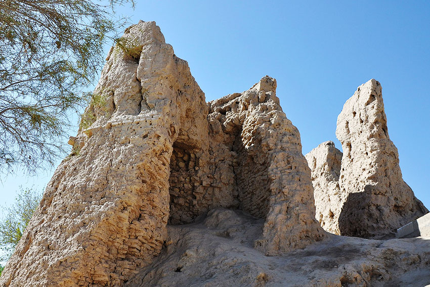
Karst is poorly developed in Big Balhan and it relates predominantly to lower cretaceous carbonate sediments. Famous Tyuz-Mergen cave is about 100 metres in length and located on the western slope of the mountain ridge. The entrance to the cave is located in the wall above precipice. After, spacious hall with 40 meters length and 5 metres height. The cave is continued through passage to another hall of 60 metres length and 20 – 40 metres width is opened. Second cave is Dum-Dum; it is located few kilometres away to the east. Its entrance is in form of niche with length of 8 metres and located between limestone stratums. Perhaps in the past, the cave could be shelter for people like those at south spurs of Balkan Mountains, which in the beginning of the last century Russian archaeologist A. Okladnikov discovered and describe caves where our distant ancestors used to live 10000 year ago. There, he discovered flint work tools of primitive man and ceramics of later period in caves Dam-dam-cheshme 1 and 2 and Jebel. . Another famous Neolithic cave camp – Kaylyu, is located on the territory of the reserve on the slope of Gubasengir ridge and became the place of wonderful findings. There, at the foothills of northern-west spurs of Gubasengir, Russian scientists discovered ancient jewelleries. Until now, these places attract special attention of tourist.
Lyama-Burun Cave presents interest on the northern slope. The entrance to the cave is difficult to access as it is located in middle part of sheer precipice with height of more than 200 metres. The entrance is quite large with 20 metres width. The cave is horizontal and consists of two spaces of several tens of metres. The first spacing is 30 metres height. Narrow inclined passage leads from there to another spacing with 20 metres height and 30 metres width. The walls have leak formations of marble onyx of honey yellowish colour with large strips and silky shine. Surely, there are other natural caves in Turkmenistan, which are not known to wide circle of specialists and speleology lovers.
We visited only largest caves of mountain Turkmenistan, real underground museums of natural science. Although they are completely studied but still present large interest and can be used for organized tourism. It is a great happiness to visit and stand under the domes of these unique natural formations and personally see inexpressible beauty of crystal kingdom.
If somebody wish to see the remains of most ancient civilization and historical monuments, then tourist route to visit ancient settlements of Meshed-Missrian can be organized. Monumental constructions of X – XIII centuries like minarets, remains of palaces, mausoleums with wondering architecture, which impress by the skill of ancient architects, remained there. There is earth compacted road of 45 kilometres distance started from Bugdayly settlement to the object.
There is one place in this region, which can be of interest of tourists – last spurs of West Kopetdag – Gyaurly Gorge, where footsteps of ancient camel, which are paleontological natural monument of world importance, are remained in layers of sandstone of Neogene. The age of footprints of ancient camel is around 2.5 million years.
Mud volcanoes of Western Turkmenistan and other places of interest of Caspian region could become not only sanctuary territory that helps scientists in sorting out of historical and geological mysteries but a zone of educational tourism.