


Amul is a medieval settlement on the outskirts of modern Turkmenabat. The geographical position of Amul, like the other four cities of the Middle Amu Darya - Kelif, Zemma, Navidakh and Farap - determined the area that was convenient for crossing.
The city often became the object of research by medieval authors: Al-Istakhri, Yakut Hamawi, Al-Masut, Ibn-Khordabeg, Al-Maqdisi and others. Almost all of them in their writings write about the rich bazaars of Amul.
The origin of the name "Amul" has not been established; from the end of the 15th century it was superseded by the name Chardzhou. However, on European maps of the 18th - 19th centuries, you can sometimes see the former name "Amul". A city with the same name also existed in the Mazandaran velayat in the Tabaristan province of Iran, south of the Caspian Sea. Therefore, Amul on the banks of the Amu Darya was called the Jeyhun, Zemmsky or desert Amul. The last name came from the difficult deserted road from Merv to this city.
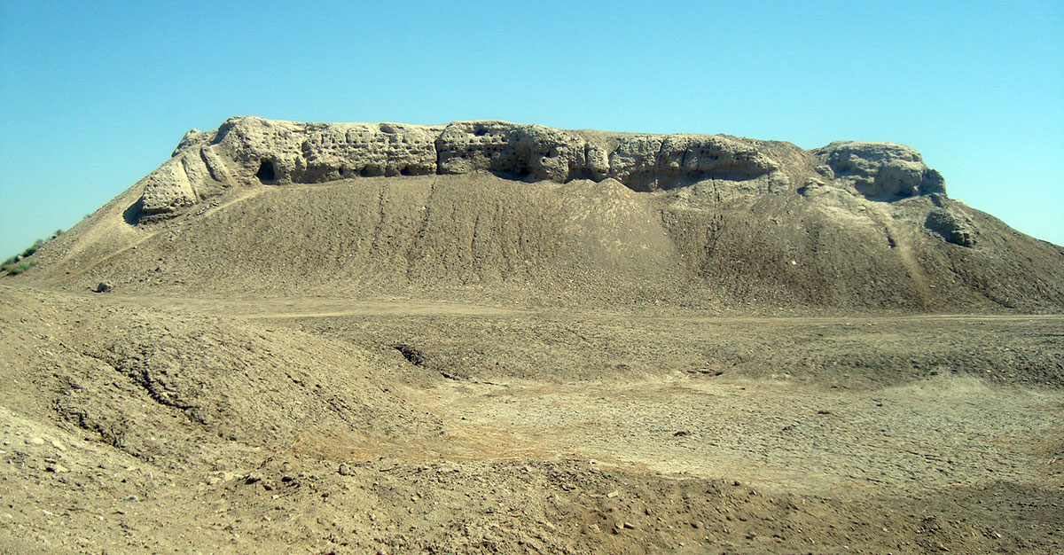
The city consisted of a shakhristan (central fortified part), a massive arch (citadel) and a handicraft and residential suburb (rabad). Shakhristan was a regular quadrangle with an area of up to 9 hectares. It lies on a multi-meter pakhsov massif, towering 21-24 meters above the district. The arch was built in the north-western corner of the fortress and was 33 meters high. The territory of the rabad that surrounded the Amul shakhristan exceeded 150-175 hectares.
Back in 1950, the VII detachment of UTAKE (South Turkmenistan Archaeological Complex Expedition) under the leadership of Galina Anatolyevna Pugachenkova for the first time established from the content of cultural layers the existence of a citadel here in the late slave-owning time, about which there is no information in written sources, and on one of the suburban hillocks they discovered ruins of the mausoleum of the X-early XI century.
A period of crisis has been traced in the history of the city since the 4th century, archaeological materials from the 5th-7th centuries are absent.
After the Arab conquest, Amul was revived and by the 9th century it became one of the largest centers of international trade, which contributed to the notable growth of the city. There was an important point on the Great Silk Road, where caravan routes crossed from West to East (from Merv to Bukhara and further to China), as well as from North to South (from Gurganj to Balkh and further to India). In 1220, Amul was destroyed by the Mongols.
The next significant stage in his life begins in the 15th century. For several centuries it was part of the Bukhara Emirate and served as a strategically important point on the crossing of the Amu Darya. Until the twenties of the last century, one could still see the fortress walls surrounding rabad, and the palace of the Charjui bey, which towered over the entire city. It was destroyed after the capture of the city by the Red Army in 1920. Since 1991, Amul has been under the jurisdiction of the Kerkinsky State Historical and Cultural Reserve.
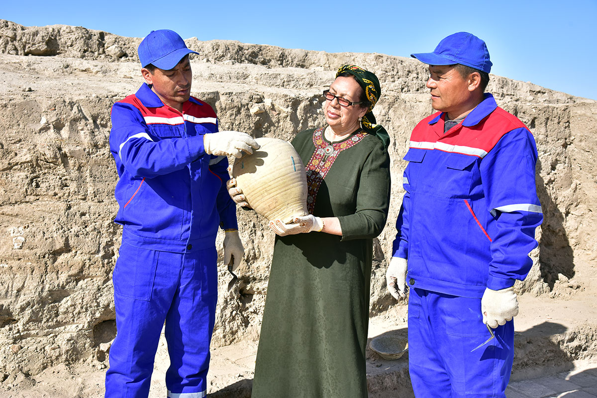
It is not the first year that Turkmen specialists have been studying the richest archaeological material, deploying field work near the settlement. Nurgozel Saryevna Byashimova, candidate of art history, chief researcher of the Institute of History and Archeology of the Academy of Sciences of Turkmenistan, told the site's correspondent about the most interesting finds made recently:
"At the end of 2017, the respected President of Turkmenistan Gurbanguly Berdimuhamedov approved the State Program for Archaeological Excavations at Monuments located on the territory of Turkmenistan along the Great Silk Road."
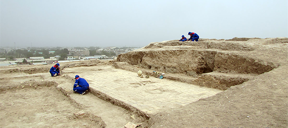
Since 2018, within the framework of the program, archaeological excavations have been carried out at the Amul settlement. Since then, work has been carried out at the Erkgale citadel, in a residential area, as well as a stratigraphic pit.
During the excavation of the residential area, a large kitchen was discovered. The fact that the room served as a cooking place is evidenced by a large amount of ash, numerous fragments of bones of large and small animals, as well as a large number of fragments of ceramic products.
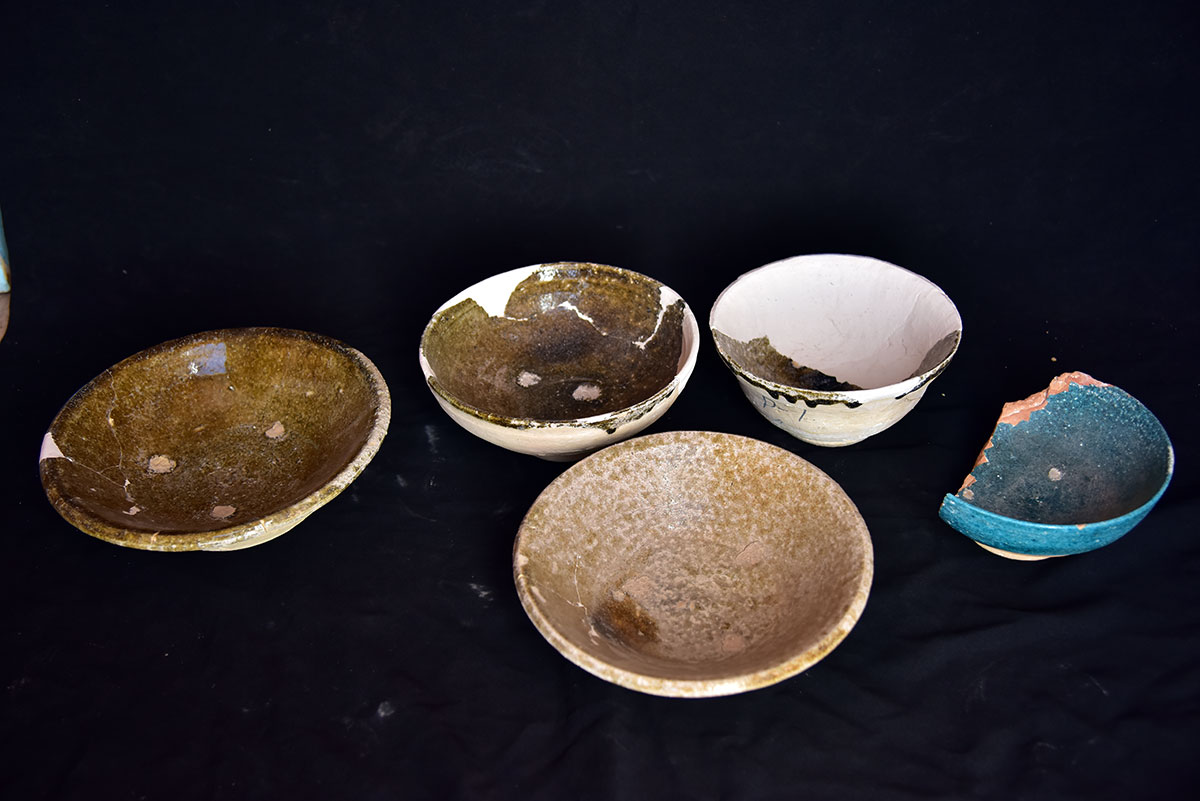
During the excavations, interesting finds were made: for example, fragments of glazed ceramics of the medieval period were found on the upper, late layer of the citadel, but, in general, the finds of the citadel belong to the late period. At the first excavation of the citadel, unglazed jugs and glazed thick-walled bowls and bowls of the XVIII – XIX centuries were discovered.
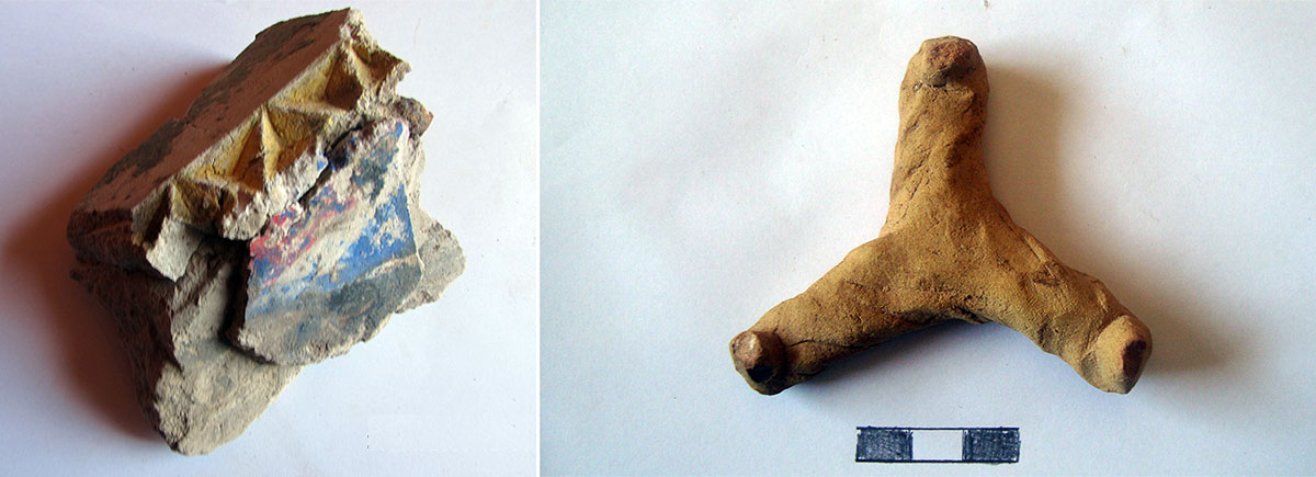
On the citadel in the premises of the second excavation, a terracotta seal was discovered with the image of a graceful animal with large curved horns, possibly a deer, around which there are stuck, clay round plaques. The diameter of the seal is 5 cm, the length of the handle is 5 cm. The seal of the same size, but with the image of a horse, head of a bull, a bird and an ear, was found by Viktor Nikolayevich Pilipko at the antique monument of Murzebegkala in the Kerkinsky etrap. The seals were probably used to mark cargo on caravan routes, as evidenced by the found clay bulls with an imprint of seals on Gobeklidep, which is located in the Karakum etrap of the Mary velayat.
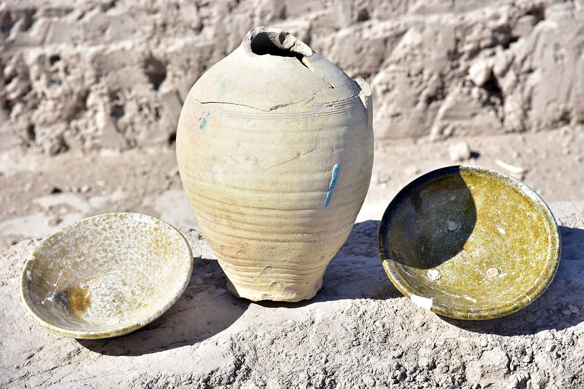
Of particular interest are bowls - a local imitation of Chinese porcelain "celadons", where imitations of Chinese characters were placed on the outside of the bottom.
Findings from glass and stamped ceramics prove that the lower tier of the pit belongs to the 9th-13th centuries. Among the glass fragments is the neck of a decanter with a drain. Another interesting find is a stamped terracotta lid with a diameter of 25 cm.On a wide strip around the handle of the lid, relief stamped repeating images are applied - a hare in the paws of a fantastic beast.
In the future plans of scientists, the continuation of the excavation of the pit to clarify the dating of the lower layers.
Roman Teplyakov