

The north of Turkmenistan is characterized with severe and contract landscapes where steppe plains of Ustyurt ends with stiff cliffs and below until the horizon the boundless Garagum stretches. But yet five hundred years ago everything was different. Here in the lower course of the Daryalyk – the ancient course of the Amyderya – there flourishes oases with several fort cities, numerous villages and thousands of hectares of irrigated lands. It is difficult to believe that if not these ruins and hardly visible trenches from irrigated canals lost in the vast fields of the Sarykamysh. The Daryalyk is the main artery of water in this region and was formed in the 13th century: no matter how it looks paradox as a result of damages, made by the Mongolian conquerors to Khorezm. They destroyed the dam on the Amyderya and the swirling water flooded first the capital city of Gurganj (present Koneurgench) and then the Sarykamysh depression and Uzboy by which in the far remote past the Amyderya fell into the Caspian sea. From this irrigation, Turkmens made use of successfully creating here at the end of the 14th century a grandiose irrigation network of facilities. Perhaps, the fort city of Ak-gala appeared on the bank of one of tributaries of the Daryalyk. It protected by the mount of Butentau with its stiff cliff hanging over the river in the north.
Butentau is well studied by archaeologists who have found here three very ancient townships: cave town, Muslim cult complex of Ibrahim Sultan with a necropolis, masjid and tower as well as mentioned medieval city of Ak-gala at the piedmont of the plateaus.

Very earlier , about two thousand years ago in those days when Uzboy was still full-watered and navigable on one of the its rocky banks which formed here a narrow and picturesque canyon, Parthians built their northernmost outpost – presently its ruins are known as Igdi-gala. Walls of this fort were made of flat stone slabs and fortified with direct-angled towers. Igdi-gala played an important role in relation with nomad steppes and the Parthian empire and was necessary for controlling the waterways from India to the black sea.
There was a whole network of ancient and medieval cities in the land of present Dashoguz etrap and they were located on the banks of one of the large tributaries of the Amyderya such as its old course Daryalyk and ancient canal Chemenyap. In the first millennium AD there appeared Gurganj (Koneurgench), occupying a favorable position on the crossroad of trade roads from south to northwest, to the Volga River and to south, to Mongolia and China. By 995, becoming capital city of whole Khorezm, Gurganj was already considered the second capital city of the Samanids after Bukhara in Central Asia.
The city of Gurganj with a total area of about 640 hectares was enveloped with the walls kept in the form of rampart stretching for 10 kilometers slightly raised to ground. The citadel, known as Ak-gala is located in the southeast corner of the former city occupying about 1 kilometre in circumference. It was fortified with powerful two-meter sun-dried brick walls and towers. Near the southern wall the water of the Amyderya ran. Medieval authors write of numerous quarters and two royal courts of the 10th century, wonderful gardens on the outskirts and a large canal crossing Gurganj.

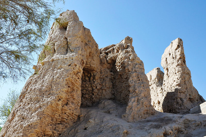
There have been left just walls of forts from numerous provincial city-forts of Khorezm serving centres of agricultural regions. However, they demonstrate rather rare system of fortification. So, besides central walls and towers there were built the second range of walls with their autonomous set of bastions. Special attention was attached to the entrance: the idea of labyrinth was obviously displayed its attribute in the fort of Izmikshir not far from present Dashoghuz. Its sun-dried brick walls cover irregular forms of the city of antique origin and possess a number of double-layered towers and from north and south there are two strong private premises.
The period of the Kushan kingdom is considered one of the glorious pages of the ancient history of Turkmenistan and it incorporated Khorezm (kingdom of Kangha) and left bank of the Amyderya about two thousand years ago. Monuments of pre-Islamic Khorezm the culture of which chronologically belong to the time of the dynasty of Afrigids, takes a very important position in the history of architecture of entire Central Asia. It is in the period of early Middle Ages (first of all in the 6th-8th centuries) there were developed those characteristic architectural traditions and forms which further assumed a wide popularity and fro a whole thousand year defined the specifics of many features of Central Asian architecture.
In the pictures: walls of Izmikshir fort; arch in the interior of one of the buildings of Shasenem.
Butentau is well studied by archaeologists who have found here three very ancient townships: cave town, Muslim cult complex of Ibrahim Sultan with a necropolis, masjid and tower as well as mentioned medieval city of Ak-gala at the piedmont of the plateaus.
Very earlier , about two thousand years ago in those days when Uzboy was still full-watered and navigable on one of the its rocky banks which formed here a narrow and picturesque canyon, Parthians built their northernmost outpost – presently its ruins are known as Igdi-gala. Walls of this fort were made of flat stone slabs and fortified with direct-angled towers. Igdi-gala played an important role in relation with nomad steppes and the Parthian empire and was necessary for controlling the waterways from India to the black sea.
There was a whole network of ancient and medieval cities in the land of present Dashoguz etrap and they were located on the banks of one of the large tributaries of the Amyderya such as its old course Daryalyk and ancient canal Chemenyap. In the first millennium AD there appeared Gurganj (Koneurgench), occupying a favorable position on the crossroad of trade roads from south to northwest, to the Volga River and to south, to Mongolia and China. By 995, becoming capital city of whole Khorezm, Gurganj was already considered the second capital city of the Samanids after Bukhara in Central Asia.
The city of Gurganj with a total area of about 640 hectares was enveloped with the walls kept in the form of rampart stretching for 10 kilometers slightly raised to ground. The citadel, known as Ak-gala is located in the southeast corner of the former city occupying about 1 kilometre in circumference. It was fortified with powerful two-meter sun-dried brick walls and towers. Near the southern wall the water of the Amyderya ran. Medieval authors write of numerous quarters and two royal courts of the 10th century, wonderful gardens on the outskirts and a large canal crossing Gurganj.
There have been left just walls of forts from numerous provincial city-forts of Khorezm serving centres of agricultural regions. However, they demonstrate rather rare system of fortification. So, besides central walls and towers there were built the second range of walls with their autonomous set of bastions. Special attention was attached to the entrance: the idea of labyrinth was obviously displayed its attribute in the fort of Izmikshir not far from present Dashoghuz. Its sun-dried brick walls cover irregular forms of the city of antique origin and possess a number of double-layered towers and from north and south there are two strong private premises.
The period of the Kushan kingdom is considered one of the glorious pages of the ancient history of Turkmenistan and it incorporated Khorezm (kingdom of Kangha) and left bank of the Amyderya about two thousand years ago. Monuments of pre-Islamic Khorezm the culture of which chronologically belong to the time of the dynasty of Afrigids, takes a very important position in the history of architecture of entire Central Asia. It is in the period of early Middle Ages (first of all in the 6th-8th centuries) there were developed those characteristic architectural traditions and forms which further assumed a wide popularity and fro a whole thousand year defined the specifics of many features of Central Asian architecture.
In the pictures: walls of Izmikshir fort; arch in the interior of one of the buildings of Shasenem.