

For almost twenty years, the talented teacher and researcher Igor Vsevolodovich Chernysh continued his studies of artificial cave settlements in the north of Turkmenistan. For several years in a row, the group headed by him examined the hard-to-reach cave cities of the Sarykamysh depression, which lies at the southeastern edge of the Ustyurt plateau (northern Turkmenistan). They discovered five cave cities located in the cliffs of hills, explored more than 200 caves and about 600 entrances, and made topographic plans. The expedition discovered in some caves of Sarykamysh runic letters similar in elements and general outline to the letters of the Scandinavians and Türks - inhabitants of Siberia and Central Asia. However, the discovered letters are not yet readable. Today, using the materials of the researcher, we will tell you about the mysterious cave cities located in the north of the country.
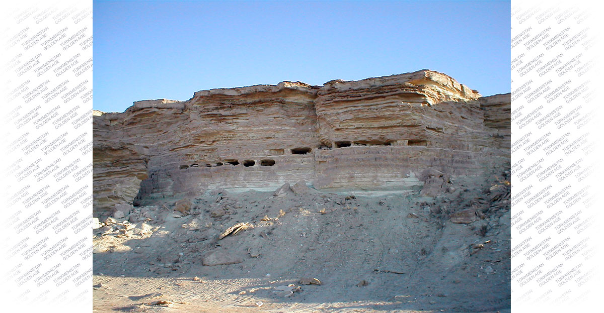
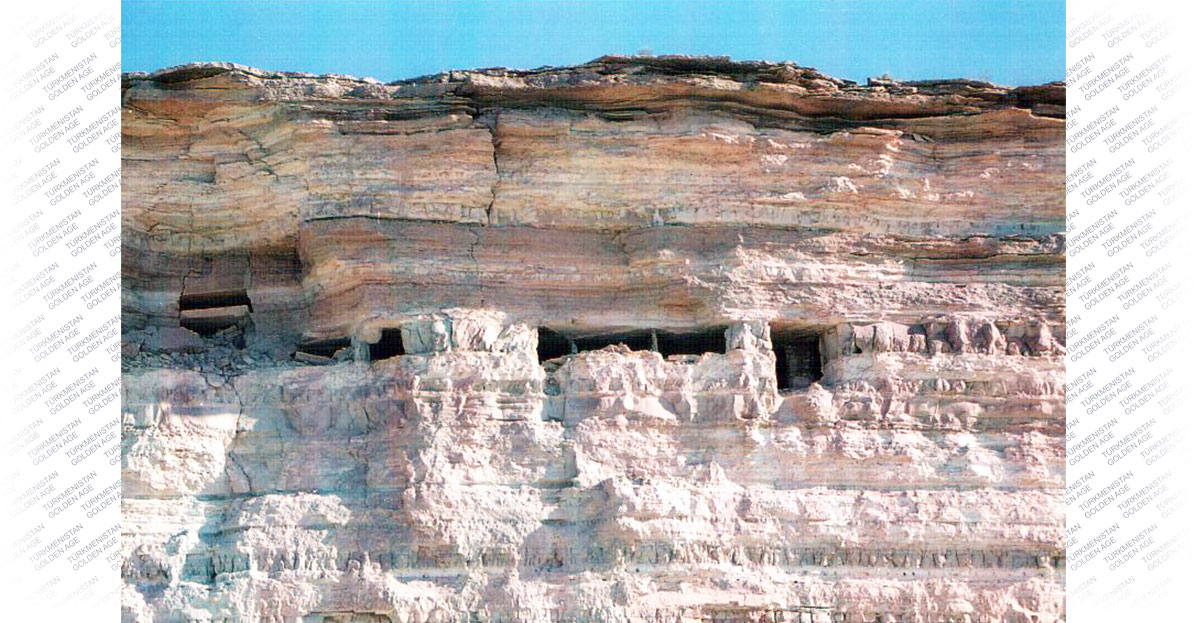
The Sarykamysh delta is an ancient Upper Quaternary delta of the Amu Darya and is a flat sandy-loamy plain bounded in the north by the cliffs of Ustyurt. On the territory of the delta, directly adjacent to Lake Sarykamysh, there are a number of outliers. The largest uplands with steep or steep slopes are Butentau, Tarym-Kaya, Zengi-baba, Kanga-gyr, Tuz-gyr. In two of them, namely in Butentau and Tarym-kai, as well as in the southern cliffs of the Ustyurt cliffs, at an altitude of 15-20 meters from the upper edge of the talus, there are caves cut by man.
Both the bottom and the top of the caves are practically inaccessible, since they are located on completely steep sections of the chinks, and often under the cornices protruding two to three meters. Corresponding member of the USSR Academy of Sciences, researcher of ancient Khorezm, Sergei Pavlovich Tolstov was the first of the professional researchers to draw attention to these caves. In 1951, having examined one of the caves accessible from below, and found pottery of the 12th-13th centuries in the talus under it, he attributed the existence of the cave city to the early Middle Ages. However, according to him, the reasons for the emergence of such a peculiar isolated settlement remained unclear.
Attention is drawn to the fact that in the works of the largest researchers of this region, since ancient times, there is no mention of the presence of cave settlements, although the territory of ancient Khorezm is described in detail in a wide variety of sources. Valuable information about this area is published in the "General History" of Polybius (II century BC). Detailed geographical data on the lower reaches of the Amu Darya are given by the works of Herodotus and Marcellin, medieval historians and geographers Ibn Khordabek, al-Jacobi, Ibn Rust, al-Masoudi and al-Istarhi. They write in detail about the ancient Khorezm Marquart, Barthold. However, in none of the works of these researchers, there is not the slightest hint of the existence of cave cities in this area. Then who, and why, built cave cities in the cliffs of Ustyurt, Butentau and Tarym-kai?
To answer these questions, it was necessary to examine the cave dwellings in detail. The very first works in this direction revealed the multiple colonization of cave dwellings, which is confirmed by finds in caves and on the fragments of rocks below them - petroglyphs, it was the drawings that made it possible to date the appearance of the caves earlier.
The most studied was the Butentau chink, as it also contains the largest number of caves. This remnant upland is the northernmost one. At the foot of the northeastern slope of Butentau, the Daryalyk channel runs. Opposite this group of caves are the ruins of the early medieval fortress Adak, on the site of which the late medieval fortress Ak-Kala was built, the ruins of which are well preserved to this day.
The caves were cut in a layer of marl with a thickness of 1.3-1.5 meters, and in some places they are located in two tiers. The first impression is that the chink talus is a gradual and natural process, but a more detailed examination convinces of an instantaneous and very powerful destruction such as a strong earthquake. In the chronicle of the Middle Ages, there is a mention of a powerful earthquake in 605 AH - 1208 (9), which occurred on the territory of Khorezm. In the capital (Gurgench), 2,000 people died, in the villages there are even more, two villages have completely sunk into the ground, and all this is some 100 kilometers from Butentau.
To get a complete picture of the living conditions in such caves, an experiment was carried out on direct living in a cave using a hearth. It turned out that the hearth for heating is very effective - the cave was heated very quickly, and the smoke came out through well-designed chimneys in any direction of the wind. The cave cooled down slowly, giving off heat due to the use of canopies, niches, for the fastening of which were found in many caves.
Some of the caves, and especially the one-room ones, were, apparently, warehouses for firewood and food. However, the possibility of the cult nature of some of the premises is not excluded. This is especially observed when exploring caves in the Tarym-kaya chink. The absence of couches, but the presence of several rooms carved into one of the walls, where a ray of light falls at a certain angle, a cross of the Maltese type and other objects make you think about the clearly cult purpose of the room.
The finds in the caves are varied, but few. Ceramics is mainly represented by fragments of vessels for storing cereals and seeds. Found a wooden dish, a wooden hollowed-out pot, many wooden combs, wool comb, spindles, various hooks. However, the most important finds in and around the caves are petroglyphs. Most of them are carved on rock fragments, chink walls and inside caves. The petroglyphs of the Sarykamysh region are very diverse both in terms of the subject of images and in style. Many of them represent images of people against the background of linear geometric compositions. In some places, at first glance, incomprehensible drawings in the form of large and wide lines and furrows are applied on the walls of the caves. This is the so-called hunting and fishing theme of the final phase of the Neolithic era. This time includes images of fishing nets, boats, dogs with their tails raised, hunting scenes.
Quite a significant part of the rock carvings of the Sarykamysh region is located in close proximity to a unique landscape monument - a narrow and deep canyon of the ancient channel of the Kanya-Darya (Daryalyk), in the depth of which, along the entire width of the river, there is a drain about five meters high. Just opposite the sink, in the steep wall of the Ustyurt chink, in the Dekcha cape, there are entrances to a vast cave carved into the rock called Besh-deshik, which means “Five holes”. There are many scratched drawings on the walls inside the cave. Basically, they are all united by several plots - these are images of animals, boats, as well as astral themes and various solar signs. Everywhere among the petroglyphs there are scenes with rams, saigas, goats, horses, camels.
The symbolism in the depiction of individual parts of the body of animals, more often than others - horses - is of a cosmic nature. The head of a horse among the ancients meant the morning dawn, the eyes - the sun, the body of the animal - the year, the hooves - the earth, the front part of the body - the rising sun, the back part - the setting sun (according to Academician BA Rybakov). It is these images of animals that are very often found in the petroglyphs of the Sarykamysh region.
Some images that deserve close attention have not yet found their explanation - this is, first of all, the image of the "ancient calendar". Groups of petroglyphs related to the so-called signs of fertility are of great difficulty in interpretation. This, apparently, can be attributed to stylized images of snakes, animals with young, hollowed out over the images of domestic animals pits and cruciform tamgas.
Most likely, the first inhabitants of the caves who created them, and the rock paintings were applied in the form of thin lines and nets, boats and astral signs, totem images. This is indirectly confirmed by images on the outer parts of the entrances to the caves and which can serve as protective signs. Thus, it is reasonable to assume that the first stage of construction and settlement of the caves dates back to the 7th century BC. NS. The subsequent stages of construction and settlement of the caves are associated with the presence and absence of water in the Sarykamysh region. It, apparently, can be associated with the first centuries of our era and the appearance of runic signs can be attributed to the same period.
And finally, the later periods of settlement date back to the Mongolian and post-Mongolian periods, up to the 17th century. This division, in addition to petroglyphs, runic writing and inscriptions, can be confirmed by the presence of six mats on the floor of the caves, separated by a compressed layer of dust 8-20 centimeters thick and various types of these mats, which indicates their different timing. The beginning of the gradual desolation of cave settlements begins, apparently, from the beginning of the XIII century, after a very strong earthquake in 1208 (9). After this earthquake, most of the caves were destroyed, and construction of the second floor began. There are no petroglyphs on the second floor.
Prepared by Vladimir Komarov